Hillside Allotment Nature Reserve Consultation – Ends 5pm 26th July 2021

posted in: Public Consultations | 0
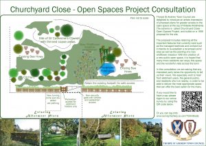
To ascertain the views of local residents on the proposed plans to turn the northern section of the Hillside allotments site into a publicly accessible Nature Reserve

Please see the plan below which details the proposals. The consultation response form can be found here

The proposed site is located at the Northern top of the Hillside allotments, sharing its boundaries with Elizabeth Avenue to the North and Hilly Plantation to the East. Archaeological digs conducted in 1951-53 and again in 1999 concluded that the site dates to the late Saxon period (evidence of domestic rubbish pits). A church and burial ground occupied the North East corner of the site as it is now. Records date a church being present from 1050 – 1555 when is was then demolished. Between the 17th – 19th Century the site was known as the ‘Old Thorpe Churchyard’. There is some question as to the name of the former church; with some maps naming the area as the former site of St Catherine’s and later evidence supporting that the site was of the former church of St Andrews. The area was presumably cultivated as allotment plots until human remains were uncovered during the archaeological digs in the 1950’s. A subsequent dig in 1999 was to define the extent of the remains of the church and associated burial ground. The council decided to establish the area as a ‘nature reserve’ in 1996 with management proposals sought from the Norwich Fringe Project in 1997 and a further management rationale report conducted in 1999. In 2011 the area had clearance works and establishment of an orchard of historic Norfolk varieties of apples in partnership with Broadland District Council's "Putting the Bee back in Broadland" community wildlife scheme. The site is currently home to an estimated 18 beehives and is generally used as a vehicle turning circle and car park for allotment garden tenants. 2. Project Scope The progression of the site and an appreciation of its flora and fauna will be to make the space open for quiet public recreational and educational use. · Areas of heavily overgrown wooded copse will require thinning to promote understory flora and fauna · The existing ‘pond’ needs the be remodelled to establish a stable marine habitat · Further establishment of wildflower/grass meadows · Creation of and alternative vehicle turning area with disabled car parking space · Establishment of ‘nature’ area boundary with the installation of vehicular restriction gates/pedestrian access points etc. 3. Deliverables There is a need for quiet secure places that not only permit wildlife to flourish but give spaces for reflection. This project will provide: · Manageable wild habitat · Additional secure ‘open space’ · Partnership with educational agencies (schools and SEND units) 4. Affected Parties To mitigate the loss of vehicular turning facilities for allotment tenants, it is proposed to convert part of a vacant garden plot to a hard-standing turning area. 5. Implementation Plan The area will be zoned to permit priority improvement works. 1. Establish boundaries and newly established vehicle turning area and install boundary fences/gates 2. Thin existing ‘orchard’ boundary line to promote light 3. Crown thin large Oak North of the ‘orchard’ to promote light 4. Thin existing wooded copse areas 5. Establish new wildflower meadow/grassland areas